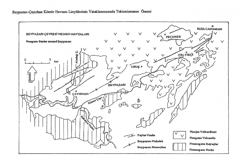
Beypazari-Cayirhan lignite region, has been settled in the north and northeast parts of Cayirhan which is 30 km to Beypazari and 130 km to Ankara (Figure 1). The region is extremely important for economic reasons.
The lignite potential, which is known possibly as 262.05 million tonnes, has been operated by Park energy. In the region, there have been 2 widely exposed lignite horizon, composed of a lower horizon of approximately 3.0 m coal vein and an upper horizon of 1.40 and 1.50 m coal seams.
The basement rocks which form the major part of Neogene, vary from Paleozoic to Oligocene.
Metamorphic schists have been composed of fine, medium cleavaged micaschists, epidote-albite muscovite schist, serisite schists, and sometimes lead black colored phillites. The basement of this series could not be recognized in the field and has been dated as Paleozoic based on the previous studies.
Granites have been exposed in the southern part of the study area. While, granites of Middle Sakarya region has been dated as Late Trias-Pre Lias, the granites of Saricakaya region in the eastern part has been settled during Permo-Trias. Senturk and Karakose (1981).
It has been easily recognized in the field with its red wine colors and has been seen as a grading of conglomerate, sandstone, silt, and clay. Layers vary between 10 and 130 cm. Formation has been deposited in a delta environment in 1.5 km southern part of the region. Conglomerates, which have been produced from quartzite and Jura carbonates, have a very well roundness in spherical shape. Matrix, which is red in color, has been composed of fine sand, silt, and clay. In this cross layering, there have been commonly yellow colored silt sandstones in the topset layers. This situation is an evidence for the length of the period of these layers under flood water. Fore deltas have been rapidly filled up with coarse sized material carried by floads. In the northern part of Sekili village, Paleozoic aged schists have been settled over these layers. The age of formation has been determined as Paleocene-Oligocene in different studies (Stchepinsky, 1961; Goktunali, 1963; Ketin, 1966, Kavusan 1989, 1992).
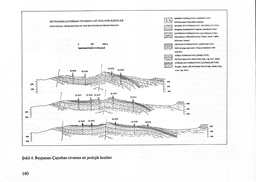
In Miocene deposits, there have commonly seen lateral and horizontal changes due to the syn-sedimantary tectonic effects (Figure 2).
Coraklar Formation
This formation have been composed of the lower layers of Neogene conglomerata, sandstone, siltstone, and clay. The base conglomeratas are fluvial in character having pebbles made of schist, calcerous, quartzite and have been settled over the base units with a disconformity. The groundness of materials can be classified as medium-low in degree. Since the type of pebbles and type of matrix have been majorly determined by wall rocks, the matrix have been composed of reddish clay-silt and some calcium carbonate. The channel injected structures have been restrictedly observed in northern parts of Karakoy. Due to the volcanic effects, the 3 to 5 m semi layerings of tuffs have been observed. Formation, changes into organic material rich grey, blue-grey mudstones and coal seams in the upper parts. Based on the drilling studies in this region, a lower horizon made of 2-4 m lignite seam has been observed. Upper lignite horizon settles over the upper parts of Coraklar formation and made of 1.40 and 1.50 m. of two coal seams.
Hirka Formation
This formation has been made of cyclothem marls of Neogene deposits. The Hirka formation which is settled concordantly over Coraklar Formation, have a layering of upper lignite horizon at the base, bituminous clay, clay schist, some tuffs, and marns to the upper parts. There have been some calcium carbonate intercalations observed in this 75-250 m formation.
Akpinar Formation
Akpinar formation has been made of karstic carbonates and blue to blue-green colored marl to the upper parts. Carbonates have large karstic cavities due to their easily soluable character and Cayirhan canalization has been drained through these cavities. Due to the effects of volcanism, formation is in rigid in character to the eastern parts. There have been a number of Causcasotachea phyrgomysica indicating the age of Tortonian. Marls can be easily recognized with their common blue-green colors and inter-layered with andesitic tuffs and tuffs. The silisic and chert intercalated carbonates of this formation have been commonly observed in the vicinity of Cakiloba village. The thickness of formation varies between 140 and 250 m based on the field relations and drilling data.
Cayirhan Formation
Formation has been composed of clay marl, carbonates, and tuffs. With its green and brownish green color, it has been overlain in the vicinity of Cayirhan. This formation has also been overlain by a intercalation of conglorematic sandstone, silt, clay, and white colored carbonates in the southern part. This intercalation has been deposited as a sediments of shallow lake carried to the southern part during the replacement of Cayirhan dome by the synsedimantary tectonic movements. Cayirhan formation has been observed in western part of Cayirhan and eastern part of Zaviye village with the intercalations of lake marls and tuffs.
Bozbelen Formation
This formation has been settled over Cayirhan formation and other older units of basement rocks. It has been consist of light red, grenish coarse pebbles and some conglorematic silt and mudstones with a grading of large to small from lower to upper parts of the unit. They develop from north to southeast in the form of aluvial fan deposits. There has been imbrification in the pebbles of conglomerata. The red colored mudstones of base units of this formation are intercalated with gypsum Kirmir formation both in lateral and vertical direction. The thickness of Bozbelen formation varies between 50-150 m in the southern part of Cayirhan Dome and 150 m in Bozbelen cliff.
Kirmir Formation
This formation settles on Bozbelen formation with a conformity. It has been composed of green clay carbonates and light green clays with gysum. The grey white colored gypsum parts have been deposited from north of Bozbelen and south of Cayirhan region to the eastern parts. This formation lies through the lower parts of Ayas in the southern region. Kirmir formation changes into micritic Sariyar lake carbonates in the western part. In the gypsum deposition coastal environment, sand silt intercalations have been dominantly observed. This stays as an evidence for environment being shallow while seasonal floods are effective in paleocoasts. During the deposition time, based on the rise of Cayirhan Dome and the movements of Davuoglan fault, Beypazari-Cayirhan basin has been developed into two basins, one lies through NE-SW direction in southern part and the other lies through N-S direction in Bozbelen region in northern part. In each basin, playa type gypsum evaporitic units have been deposited. The thickness of Kirmir formation varies between 100-200 m. In the eastern part of Cayirhan, the thickness of gypsum marls is more than 100 m.
In the Beypazari basin, volcanic rocks are in the extended form of Kizilcahamam Celtikci volcanism and are tuffs of an andesitic volcanism. Due to the existence of tuffs below upper seam, the age of volcanism can be determined as the beginnings of Miocene. The formation of trona in Hirka region indicates that the relationship between volcanism and hot water and tectonism are important. The thickness of tuff bands in Akpinar and Cayirhan formation increase in width to the northeast direction and reaches to 30 m. It commonly exceeds 200 m in the vicinity of Beypazari.
Beypazari Neogen is tectonically an interesting basin. The development of NE-SW oriented Beypazari basin has directly been controlled by tectonic movements.
In the tectonic overlapping corridor, Celtikci, Urus, and Beypazari basins have been developed (Fig-1>. Beypazari-Cayirhan basin has been affected by NW-SE oriented compressive movements. These movements have both caused by the narrowing of basin and determined the character of deposition environment. For that reason, synsedimantary tectonic has been observed perfectly. The faults in older deposits of Beypazari region have been changed into flexur surfaces in younger units.
Beypazari Monoclinal
The most important tectonic structure is Beypazari monoclinal with its monoclinic character. Beypazari monoclinal fold has been developed in the form of two en-echelon structures. In eastern part, it has been started from southeast and continued to the northeast part through Beypazari region. In western part, it has been started from Zaviye village and continued through the west part of Cayirhan. The tectonical development of this flexur has affected the basin at which totaly younger units of Bozbelen and Kirmir formations have been deposited. Due to the effect of bending, layer slopes vary between 45 and 90 degree.
Sinircam Syncline
It has been formed in the northeast part of Cayirhan. It is in the form of a asymetric sincline having layer slopes of 17-35 degree in northern and 65 degree in its southern side.(Fig-2)
Uykubasi Anticline
Uykubasi anticlinal is the rest of Sinircam senklinal in the south. From the northern part of Kuyucak village to NE of Cayirhan region, anticlinal has been broken as Davutoglan fault all through its axis. Whereas, from northern of Kuyucak to Zaviye village, there have not been any broken parts observed. While, it has an appearence of symetric anticlinal in eastern part, it changes into an asymetric appearence in the western part. This is related to the rise of Cayirhan Dome. The slopes change between 25 -30 degree and can increase to 60 degree by the effect of Davutoglan fault.
Cayirhan Dome
It exists as a paleobase which has an erosion in its center. Cayirhan Dome has been formed by the extension of Paleocene-Eocene aged series between Karakoy and Ulukoy regions and the rise of that part by the effect of Davutoglan fault's activity. Akpinar and Cayirhan formations have been formed by fine deposition of series over paleorise of dome.
However, by the effect of compressive effects of this dome structure, this block have been risen to the upper layers by destructing them similar to the removal of seed of an olive particle by the sequezzing effect of fingers. These upper layers have been exposed to erosion due to the easily destruction of layers and today's appearence has been formed.
Faults in the basin have been entirely composed of NW-SE oriented compressed overthrusts (obductions) and tearings among tectonic settings of Pontite Anatolite zone. These overthrusting faults have approximately vertical slopes with a direction of N30E. Faults in this region can be classified into two based on their formation mechanism and their direction.
These group of faults are overthrusting faults which lie parallely among each other. (Fig-2) These have been ended up in the deactified periods of younger deposits and less lithified rock groups.
Karakoy-Sekili Overthrust
This overthrust has lie in the form of en-echelon broken structures. The metamorphic base formation has been overthrusted on red colored sandstone siltstone clay intercalations of Kizilbayir formation and Kizilbayir formation has finally overthrusted on Miocene series.
North Fault
North fault zone has been settled on the northern part of Davutoglan fault and lies parallely in northeast direction to this fault. North fault have both the character of overtrusting faults and a combination of syntectic settling of other faults developed through its own direction. For this reason, it sometimes acts as a synthetic gravity oriented crack of Davutoglan fault.
Davutoglan Fault
Davutoglan fault is the most important broken part of Beypazari-Cayirhan basin. The total length of this fault is more than 40-50 m. It continues as an en-echelon broken fault of Beypazari flexur in northeastern part of Beypazari region. In the western part, its oriention is between 70 and 110 km, whereas in NE part of Cayirhan, its orientation is approximately 80 m and in the very eastern parts it reaches to 150 m. The direction of this fault is N27E. (Fig-2)
These broken structures have been formed by the effect of compressive forces caused base differences in Pre-Neogene and their effects have been continued through Neogene series. In the devopment period of these faults, the differences in vectorel amounts of different compressive forces has a major role.
Uykucayi-Iyidelidere Wrench Faults
This wrenching, has been continued to southern parts after cutting of North and Davutoglan faults. The western block of the fault has been slipped to north approximately 25-50 m.
Martlidere Wrench Faults
This wrenching have a direction of N-S in the western part of Uykucayi-Iyidelidere Faults. In this part, block has been slipped to the north approximately 50-75 m.
ECONOMIC GEOLOGY, COAL GEOLOGY
THE PROPERTIES OF COAL SEAM
Lower Seam Horizon
This horizon has only one seam spreading approximately 13.5 km2 . This coal seam is with clay in character. In the upper part of seam, tuff silts and clay and in its base part, plastic clay and clay siltstones have been included. The thickness of seam varies between 1.30 and 11.15 m. It has been bedded in the overflood part of paleomarsh region among small river canals. Macroscopically, it has an appearance of changing from lustery to solid colors with being rich in secondary minerals of pyrite and calcopyrite. Based on the palynological studies, its has been dated as Middle Miocene.
Upper Seam Horizon
The thickness of upper seam horizon varies between 2.90-4.50 m. It has been settled in the upper part of Coraklar formation. Between these two seams, there exist an intercutting layer made of volcanic fine tuff and clay with a thickness varying between 0.50 and 2.50 m. Macroscopically, it has been composed of irregular lusterous and solid bands. It has a medium hardness and a color of light black and black. Whereas, in alteration surfaces its colors changes from light brown to brownish black. Dissemine pyrites and marcasites are common minerals. In the upper parts, by the increase in the amount of inorganic matter effect, it changes into bitumness clay. It has been formed after the carrying of sediments to the deep and rapidly settled basin. Upper seam horizon of paleomarsh environment has been composed of mixed arbitrary and reed moor which has been spread out in the vicinity of coast of lake.
This excursion guide is prepared for geology student of South Dakota Mining School and the Ankara University Geology Department, JEM 206- FIELD GEOLOGY by Assoc. Prof. Dr. Gultekin Kavusan.
February-2007